Climate change is gathering momentum and because of this, the world has witnessed some of the most devastating disasters recently. Tsunamis, cyclones, floods, earthquakes and even wildfires have destroyed lives and entire regions, of late. So can we look to open source software to help mitigate the effects of these disasters?
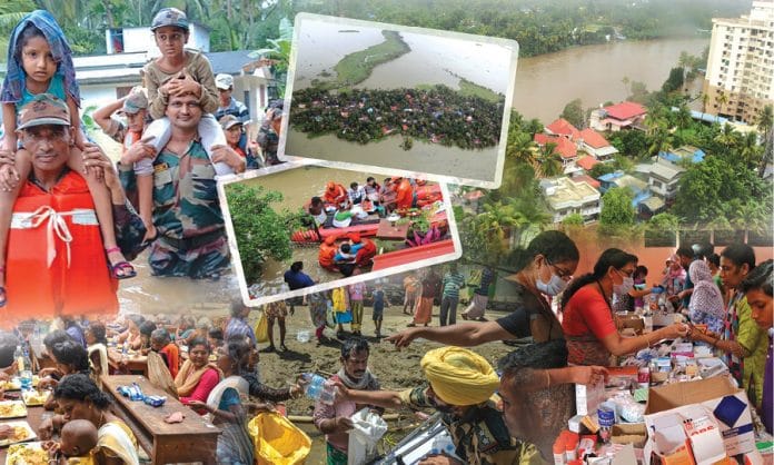
Last August, Kerala reeled under one of the most severe floods it has witnessed in over a century. In one way or another, the entire population of the state (about 33 million) was affected by this disaster. More than a million people were evacuated from their dwellings and about 500 lost their lives. The amount of damage to property and livestock is yet to be fully assessed. Though a tragedy of epic proportions, it clearly brought out the best in people. The selfless deeds of countless individuals are still widely circulated on social media. The 2018 Kerala floods also saw the widespread use of technology for disaster management.
Rescue personnel on the ground often lack information regarding the locality and the people affected during natural calamities. Communication and computation technology comes handy in such situations to provide the necessary data required for rescue and evacuation. Social media platforms like Facebook, WhatsApp, Twitter, etc, were widely used to locate and track people stranded in isolated locations due to the flood waters. Many people who were often criticised for their excessive use of social media platforms became heroes overnight because of their actions that saved countless lives. Those who were stranded in isolated locations, requested help through social media platforms and these distress calls were then verified by volunteers. Once the authenticity of a request was confirmed, it was reported to the personnel responsible for relief work. This sort of timely intervention by a large volunteer force mitigated the severity of the floods to a great extent even with large scale power outage and other logistical nightmares. In this article we will discuss ways in which computing technology was used for disaster management during the floods and also some of the other open source tools ideal for disaster management.
Web development frameworks
One of the first areas in which computing technology was used during the floods was in Web development. Government agencies, NGOs, educational institutions, etc, either made changes to their existing websites or created new ones to tackle the problems faced during the floods. There were a lot of requests for the services of Django developers on various social media platforms during the floods—far more than for any other Web development framework. Django is a free and open source Web framework, developed using Python. The reason for Django’s popularity during the flood is that it supports a rapid development model and thus is ideal for getting websites up and running quickly.
In moments of crisis, people may not care much about the look and feel of the websites, but rather about the services provided. Thus, in such situations, Django is the Web development framework to depend on. But post the disaster, environment tools like AngularJS and Node.js can also be used — both are open source Web development frameworks based on JavaScript. Node.js is mainly used to build server-side applications, whereas AngularJS is suited for building single-page client-side Web applications. I believe if different disaster management agencies have a pool of volunteer Web developers available to be deployed immediately, then the crises due to natural calamities can be managed more efficiently.
Mobile application development
During and immediately after the floods, many volunteer developers started creating mobile applications to help those affected by the flood. There are many different roles for such apps to play in a post-disaster environment. A very useful function provided by many of these apps was to create a common platform for people affected by the floods and rescue workers to interact with each other. One such app is AmritaKripa, developed by Amrita Vishwa Vidyapeetham (a research and engineering institute). It is an Android app for disaster management that connects flood affected people with relief and rescue service providers. The app is multilingual with support in Malayalam and English.
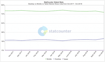
Many other apps were also proposed immediately after the floods. One project was regarding the documents and certificates lost during the floods. An app was proposed so that people can request for their lost documents through it. In a state like Kerala, where digital penetration is very high, the idea of using mobile apps for disaster management has been highly successful. Figure 1, obtained from the StatCounter Global Stats website, shows the Internet-accessing devices in India (the category ‘Desktop’ includes laptop computers also). So, in a country like ours, where far more people use mobile phones than desktops, laptops and tablets to access the Internet, mobile apps have a far more important role to play than websites.
Having discussed the role of mobile apps during and after natural calamities, the important question to answer is, “What mobile application development platform should be used during such times?” Well, I am not going to make any strong recommendations in this category but Kotlin could be a strong contender as a suitable programming language for rapid mobile app development and deployment. Though a relatively new language, for which development started only as recently as 2011, Kotlin (Figure 2) has already proved to be a mature language and environment for developing Android applications quickly. It is currently ranked 41 in the TIOBE index of programming languages and has been steadily gaining popularity over the past years. The speed of apps developed with Kotlin is comparable with those developed with Java, and in fact, it is easier to develop apps using the former. These features make Kotlin a useful app development tool during crisis situations, where fast development and deployment of apps is critical.
Inventory management software
During the floods, a lot of people were stranded in isolated locations and relief camps, needing food and other essential supplies, while at the same time, a lot of food and supplies were ready and in stock, awaiting delivery. Using social media platforms to coordinate inventory management could potentially cause a lot of problems due to the distributed nature of the medium. It is often possible that the same group of people could have made multiple requests, or the same supplies could have been promised to multiple groups by mistake. This can lead to wastage of food and other basic supplies.
Manual inventory management is a challenging issue due to the large scale evacuations during natural calamities. But this problem can be solved easily by the proper deployment of good inventory management software. One open source inventory management application is Apache OFBiz. It is a developer friendly suite of business applications that can be used to handle different scenarios. The common architecture of Apache OFBiz allows developers to easily extend and enhance it to create custom features necessary for inventory management during and after natural disasters. Other such open source apps include Delivrd, inFlow, etc, but these operate on a freemium business model in which commercial versions have a user fee, whereas Apache OFBiz is freely available for download. Thus, Apache OFBiz (Figure 3) is an ideal choice for inventory management.

Remote sensing software
Remote sensing is the process by which information about an object or place is obtained without making any physical contact, and is largely used in areas like meteorology, oceanography, geology, glaciology, etc. If accurate information is available in these fields, it can be used to predict and thereby reduce the impact of many natural calamities. Remote sensing can also be used in a post-disaster environment. For example, it can be used to find alternative routes to reach areas isolated due to floods, volcanic eruptions, etc.
Remote sensing involves passive sensing and active sensing. The former detects radiation emitted from the observed object or place. Even though passive remote sensing often involves photography, a lot of information can also be obtained by using techniques like infra-red radiation detection, radio wave detection, etc. In active sensing, an energy source is used to scan the object or place to be sensed. Analysing the massive data sets produced by passive and active sensing is a tedious and error-prone task. Due to this, a lot of geospatial toolkits are used to analyse remotely sensed data. Remote sensing software often acts like image processing software.


Some of the popular remote sensing software have proprietary licences. But we will only discuss open source remote sensing software. I really wanted to include Google Earth in this list. But remembering the animosity of many in the open source community towards freeware, I will include Google Earth Enterprise, a geospatial application licensed under the Apache 2.0 licence. It provides the ability to build and host custom made two-dimensional maps and 3D globes. Another popular tool is OpenEV, a geospatial toolkit capable of processing remote sensing data to provide 3D elevation data and geo-referencing, which is the process by which a point in a geo-sensed image is mapped to an actual location. Opticks (Figure 4) is another popular remote sensing application that can process both remote sensed images and videos. It also has the advantage of additional plugins for further extensions.
Geographic information systems
A geographic information system (GIS) is a tool used to store and analyse spatial and geographic data. A GIS can be used to highlight a cluster of points in a geographic area. One of the earliest recorded uses of a GIS was during the cholera epidemic of Paris in 1832, when the locations of people affected with the disease were marked on a map to identify the source of the epidemic. In a post-disaster environment, there is always a high probability of diseases spreading, particularly when water sources are contaminated, like during a flood. In such situations, a GIS has a huge role to play. Now let us discuss a few popular open source GIS.
QGIS is a cross-platform, open source GIS that allows the comparison and export of hard copy maps in a digital form. It also allows analysis and editing of spatial information. PostGIS is a spatial database extender for PostgreSQL, an object-relational database management system. It allows location queries to be run in SQL over geographic objects. PostGIS is released under the GNU General Public License. Another popular yet proprietary GIS is ArcGIS (Figure 5), which is used for creating and using maps, as well as for analysing such mapped information. ArcGIS also helps in managing geographic information in a database.

I would like to point out one fact before concluding this article. All the ideas mentioned here are from a layman’s perspective. Rather than vouching for the 100 per cent efficacy of any particular idea or solution, I instead hope this article will lead to a debate about speedy solutions for disaster management, which will eventually lead to better ideas than the ones presented here. However, I strongly believe that the proper use of computing technology can reduce the severity of natural disasters anywhere in the world. During such periods, governments and relief organisations are hard pressed for funds, so adopting open source technologies is the logical choice. Ideally, disaster management agencies should have a volunteer task force equipped with the necessary computing skills ready, so that it can be used to manage a post-disaster environment efficiently.


